The Best 7 Free Weather Apps for Hikers
This post may contain affiliate links. This means that we may receive a small commission from purchases through those links. Read more in our affiliate disclosure.
When planning a hiking trip, it’s crucial to keep an eye on the weather. Predictions from observing the clouds and the like can be very helpful, but can’t beat having the right app to serve as your digital forecast companion, preparing you for what Mother Nature might throw your way. Here are some top free weather apps for hikers, offering a range of features to keep you informed and safe on your adventures.
- Introduction
- What Makes a Good Weather App for Hikers?
- The best free weather apps For Hikers
- Weather Underground: Hyper-local Weather Data
- Windy: Detailed Visuals of Weather Systems
- AllTrails: Your All-In-One Trail Guide
- Mountain Forecast: Tailored Forecasts for Your Peak Pursuits
- NOAA Weather Radar Live: Real-time Weather Radar
- Meteoblue: Accurate Forecasts Down to the Hour
- OpenSummit: Aim High with Peak-specific Forecasts
- ClimaCell: Micro-weather Prediction in Your Pocket
What Makes a Good Weather App for Hikers?
Choosing the best weather app for your hiking needs depends on several key features.
Firstly, the accuracy of the weather forecast is paramount. When venturing into the wilderness, reliable predictions can mean the difference between a successful, enjoyable hike and an unpleasant, potentially dangerous, outing. Apps like Meteoblue and ClimaCell are prized for their precision, even in remote locations.
Secondly, localization is crucial. Apps that offer hyper-local weather data, such as Weather Underground and ClimaCell, can provide insights into the conditions you’ll face on specific trails or at specific altitudes, which is not something you’d get from a standard weather forecast.
Thirdly, usability and visual presentation are key. An app that displays data in an intuitive, easy-to-understand way makes planning your hike a breeze. The interactive visuals offered by Windy and the simple yet detailed layout of OpenSummit make these apps a joy to use.
Finally, specialized features can be very beneficial. Whether it’s Mountain Forecast’s elevation-specific predictions, AllTrails’ trail tracking combined with weather data, or OpenSummit’s summit-specific forecasts, these tailored tools can enhance your planning and safety on the trail.
The best free weather apps For Hikers
Weather Underground: Hyper-local Weather Data
When it comes to hyper-local weather data, few can compete with Weather Underground (Android, Apple). This app distinguishes itself by sourcing its data from a vast array of private weather stations, providing a detailed snapshot of localized weather conditions.
One standout feature of Weather Underground is its interactive weather map, which allows you to view weather data from various stations. You can see temperature, humidity, wind speed, and more at a glance. This feature can help you anticipate the conditions on different sections of your hike, particularly if you’re hiking off the beaten path. On the downside, its weather data can sometimes be too localized, which may result in inaccuracies when generalized over a larger area.
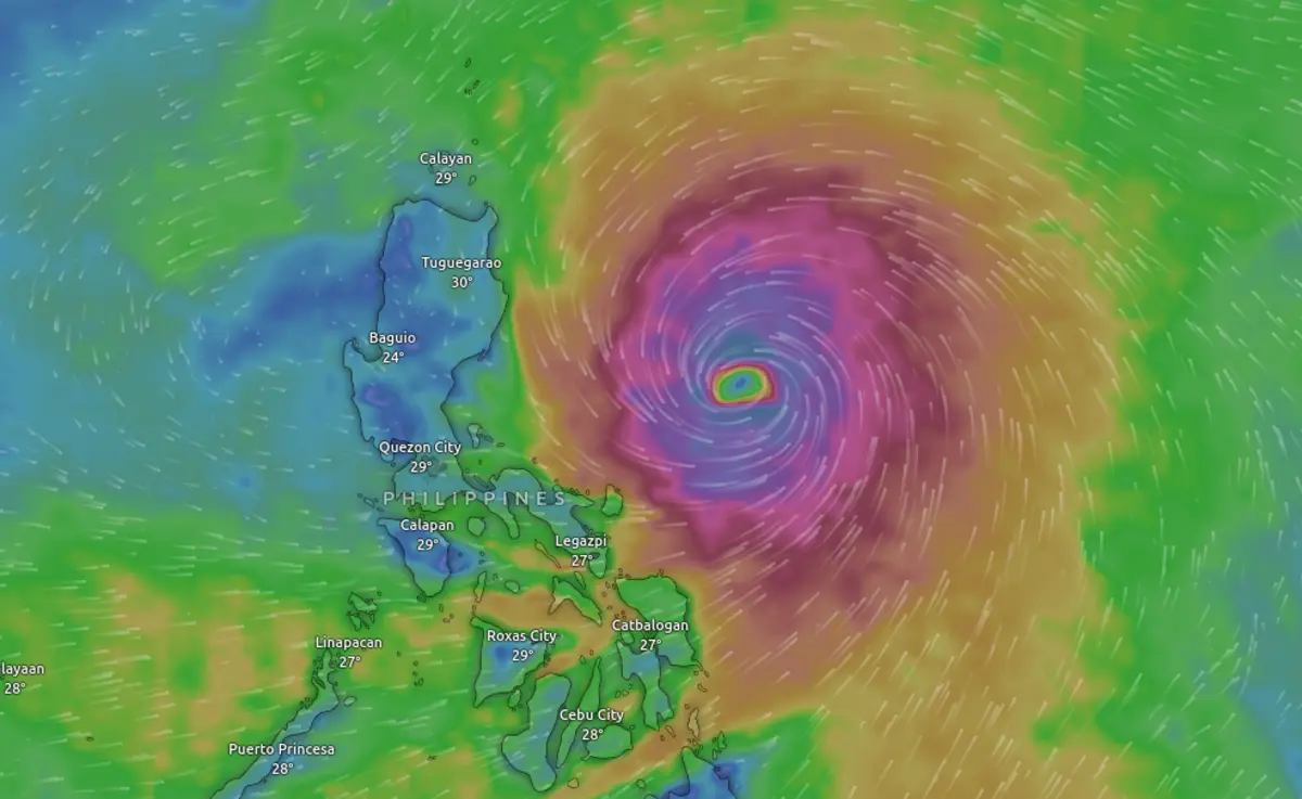
Windy: Detailed Visuals of Weather Systems
For an immersive weather experience, Windy (Android, Apple) is a top contender. This comprehensive weather app offers highly detailed and interactive visuals, including wind patterns, temperature gradients, and more. For hikers who appreciate a visual overview of weather systems, Windy provides a near real-time, captivating display of weather patterns unfolding around the globe.
The app also offers a useful feature for hikers: the ability to overlay different weather parameters on the map and see a visual interpretation of conditions such as wind speed or temperature at different altitudes. While Windy provides a wealth of information, it may take some time to get familiar with interpreting the data. The visual-heavy interface, while impressive, can be overwhelming for those used to more traditional weather apps.
AllTrails: Your All-In-One Trail Guide
AllTrails (Android, Apple) may primarily be a trail finding and tracking app, but its provision of weather information makes it an excellent all-in-one solution. It offers weather forecasts for trail locations, allowing you to understand the climatic conditions you’ll encounter on your hike. AllTrails also boasts a robust user community, enabling you to see trail reviews and photos from other hikers.
However, while AllTrails provides a good overview of the trail and weather conditions, it’s not as detailed or specialized as some other weather-specific apps. For instance, the weather forecast doesn’t provide as much hourly detail or weather data (like humidity levels or UV index) as some other dedicated weather apps.
Mountain Forecast: Tailored Forecasts for Your Peak Pursuits
Mountain Forecast stands out as an invaluable tool for hikers due to its unique approach to weather forecasting. Unlike generic weather apps, Mountain Forecast provides weather predictions for specific elevations on mountains all around the globe. This unique feature makes it an ideal choice for anyone planning a hike, as it provides weather information tailored to the precise elevation of your planned route.
However, be aware that while the app’s elevation-specific forecasts are useful, they may not account for microclimates or sudden weather shifts caused by local geographical features. Therefore, always complement the information from the app with local advice and observations.
NOAA Weather Radar Live: Real-time Weather Radar
When hiking in the United States, the NOAA Weather Radar Live app becomes a vital asset. This app offers real-time weather radar data, along with detailed weather forecasts, directly from the National Oceanic and Atmospheric Administration. This provides you with the most accurate and up-to-date weather information possible.
The app’s radar functionality is particularly useful, allowing you to visually track storms and weather fronts in real time. For hikers who need to keep an eye on quickly changing weather conditions, this can be an invaluable tool. However, the radar functionality does require an internet connection to update, which can be a limitation in more remote hiking areas where cell service may be unreliable or non-existent.
Meteoblue: Accurate Forecasts Down to the Hour
Accuracy is paramount when it comes to weather forecasting, and that’s where Meteoblue (Android, Apple) excels. Known for its impressive precision, this app provides detailed hourly weather forecasts. Its hiking-specific forecasts focus on temperature, precipitation, and wind at various altitudes, providing you with a wealth of information for planning your outdoor adventure.
Meteoblue also offers a unique feature called the “Meteogram,” a graph that shows the forecast of several weather elements over the next few days. It allows you to visualize the weather trend, which can be especially useful for planning multi-day hikes. However, the level of detail provided by Meteoblue can be a double-edged sword, potentially overwhelming for those who prefer a simpler, more straightforward forecast.
OpenSummit: Aim High with Peak-specific Forecasts
If your hiking preferences lean towards conquering peaks, OpenSummit (Android, Apple) is a fantastic resource. This app offers weather forecasts for over 1,000 of the most climbed summits in the U.S., making it a dedicated tool for mountain enthusiasts.
The free version of OpenSummit provides a basic forecast including temperature, wind speed, and the likelihood of precipitation. For those who want more detailed information, such as hour-by-hour forecasts, sunrise and sunset times, or freezing levels, there is a paid option. However, the app’s focus on popular summits may limit its usefulness for those who prefer lesser-known or less frequented trails. Plus, while the basic forecast is free, many of the app’s more comprehensive features do come with a cost.
ClimaCell: Micro-weather Prediction in Your Pocket
Last but certainly not least, ClimaCell (Android, Apple) has made a splash in the world of weather apps with its promise of “micro-weather” forecasting. This app aims to deliver hyper-local weather information with high accuracy, by using a variety of data sources like connected cars, drones, and even cellular signal data.
For hikers, this means you can get a weather forecast tailored to your exact trail location, not just the nearest town or city. Particularly for those venturing into remote areas, this level of detail can be invaluable. However, as with any cutting-edge technology, it’s important to remember that the forecasts, while impressive, are not infallible. The accuracy can vary based on data availability, so it’s always wise to cross-check with other sources and use your best judgment.